
US Public Lands
by Two Steps Beyond LLC
Version 10,000+ 💾 49 Mb
📅 Updated Eligible if bought after 7/2/2016.
Learn
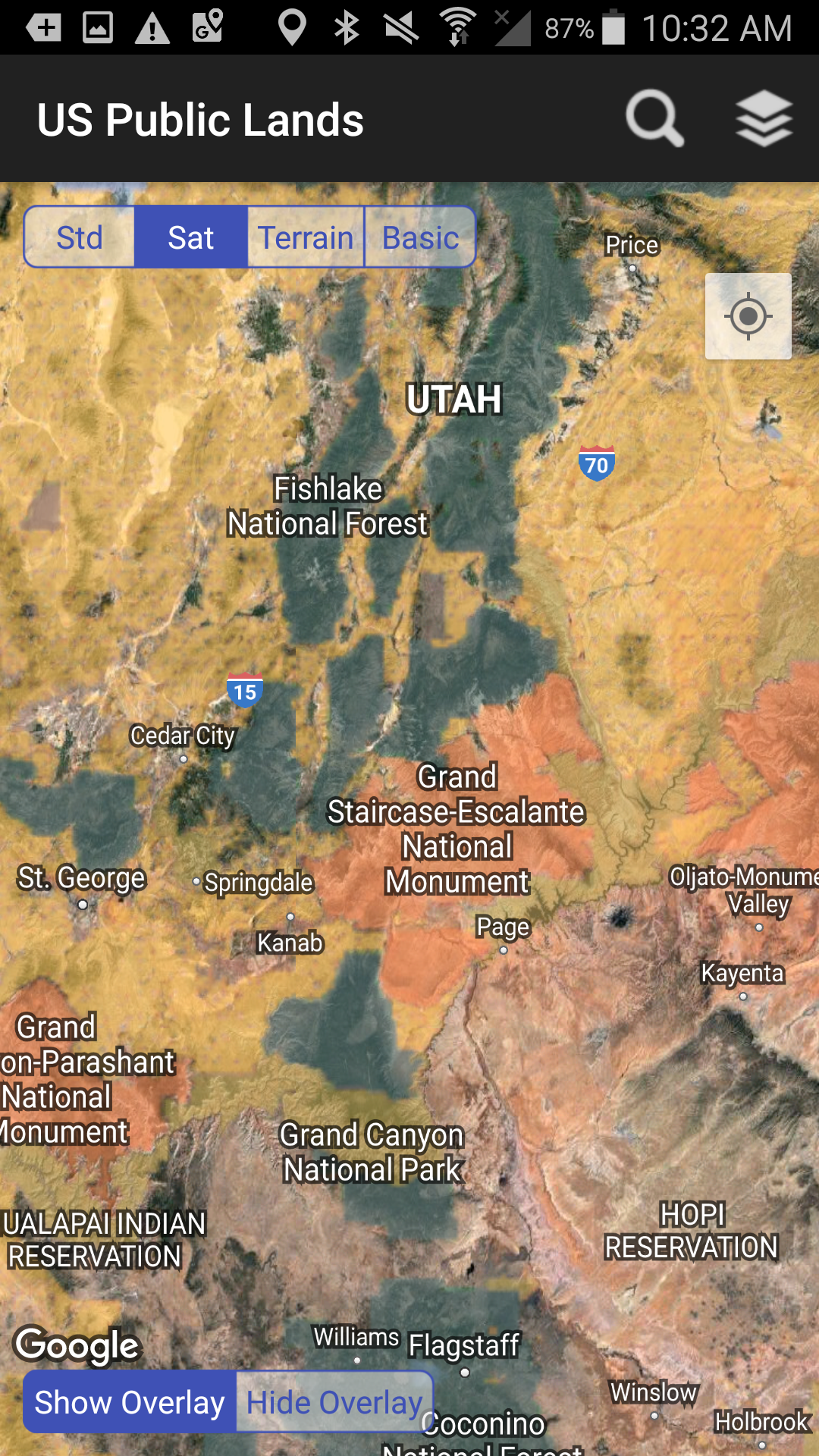
View US public land boundary maps on your device.

Features US Public Lands
The US Federal Government* owns nearly 650 million acres of land - almost 30 percent of the land area of the United States.These are lands that are held for all Americans.Up until now, there has been no quick & easy way to retrieve the boundaries of these properties without carrying physical maps, books, or slowly digging deep online.Included in this app are on device (fully works offline), individually selectable & beautifully colored layers for most of the properties administered by the federal government:- Bureau of Land Management (BLM)- US Forest Service (FS)- National Park Service (NPS)- Army Corp of Engineers (ACOE)- US Fish & Wildlife Service- Bureau of Reclamation- Tennessee Valley Authority- Department of Defense (military bases & installations)- Other (National Laboratories, Test Sites, etc...)Key Benefits & Features- Know which US agency owns and operates the land youre on or are heading to.
Use the "Layers" icon to select which agencies you want displayed to create your own custom map.
(Hint, the toggles are color coded to the color each layer is displayed in.)- Links are provided to each agencys website within the app, so that you can further your research as to what land use rules apply for each public land type - such as permits, fees, activities allowed, and limits of stay.- Map layers are stored on device - no internet connection required.- Be sure to turn on the Basic base map to see the US Public Land labels for each land area.
This base map layer is also stored entirely on your device, and can be utilized if you do not have an internet connection or would like to conserve bandwidth.- If you have an internet connection, you can utilize standard and satellite view maps as well as the base layer underneath the public land overlays.- A boondockers assistant - While US Public Lands is not specifically a camp site locator and does not have a database of specific sites, by turning on the satellite view map, you can better scout out trails, roads and signs of dispersed camping locations within the boundaries of the public land resources.
- Quickly toggle between Show and Hide via the "Map" icon to more clearly see satellite images below.- If you have GPS access on your device, click the Locate Me icon to show your present location - know what type of land youre on right now!- Built in search tool locates anything on device maps supports (requires internet access) - including cities, states, zip codes, addresses and points of interest.
A pin is dropped at the search location.Thank you to the Protected Area Database (PAD-US) of the U.S.
Geological Survey* for providing the public domain raw map data that we’ve been able to utilize to create this interactive overlayable mapping & navigation tool.
We will update our maps in the future to stay in sync with improvements to this data set.
Please note, the USGS PAD-US database contains the “most up-to-date aggregation of Federal lands and waters” available, but this database is still evolving and some locations may not be listed and others may not have precisely accurate boundaries.
Resolution across the nation may vary.
And always remember - there may be private unmapped inholdings within any public lands - so always pay attention to local signage, indications, and information.
The US Public Lands app should only be used as an overview, and you should always confirm more precise details by consulting local field offices, administration websites, and other resources.
Do not solely rely on this app for determining if you are on public or private land.*The maps included in US Public Lands were generated from data provided by the USGS.
Two Steps Beyond is not affiliated with, and does not represent, the USGS or any other US Government Agency.Corrected an issue that would cause crashes on older versions of Android when editing Pin Data.
Social Features
Connect and share with friends and the community.
Gaming Features
Enjoy immersive gaming experience with various game modes.
Fitness Tracking
Track your workouts and monitor your health metrics.
See the US Public Lands in Action

What Our Users Say
Don't just take our word for it. Here's what our users have to say about our Android app.
"Great"
Donald Woods
"Very useful for van camping"
Lee Blake
"No star just bought this and not working want my money back"
Travis Garrett
"Very cool app. to have helps u know whether u are on public or private lands"
kimberly hawkins
"This app does not load just continues to try to install and never installs"
G K
"Don't drop pins there is no clear way to remove them . Can't find anyway to clear a drop pin or to clear list of pins."
Patricia Junno
"Does what it intends to--shows you public land. Thank you for creating this! As a wanderer/boondocker, I am always looking for those BLM, USFS, trust land boundaries and accessing multiple resources trying to determine if I'm legal to park overnight in a given spot. This app does not offer a lot of functionality, but for $3 I have no regret for having an app where I can immediately check my location and determine if I'm on public use land or not. I have not noted any inaccuracies."
Shannon
"Comparing this to other apps, which are free, this has less functionality. Doesn't do anything besides show regions/blm/other/etc. Nothing to see here."
Peter Martincic
"This app works in the mountains when nothing else does"
Jack
"Revise"
Erik Lopez
Get the App Today
Available for Android 8.0 and above